The projects within the different research domains make my job at Witteveen+Bos challenging and fascinating
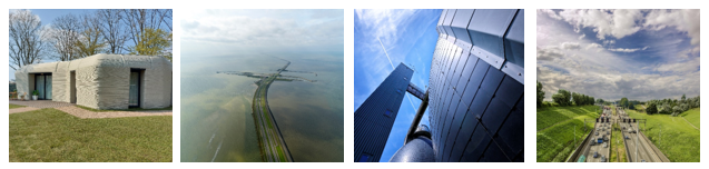
Frank works as a Data Scientist at Witteveen+Bos engineering and consultancy. Their engineers work on projects within the research areas:
- Built environment
- Deltas, coasts and rivers
- Energy, water and environment
- Infrastructure & Mobility
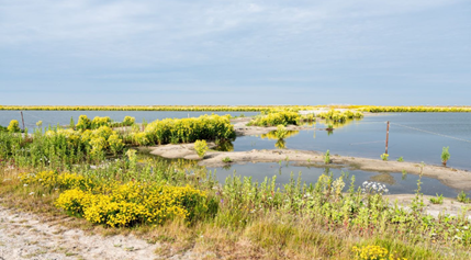
Vegetation monitoring at Marker Wadden
One of the most interesting projects that I have been working on is of the monitoring of vegetation at Marker Wadden. This artificial archipelago located in the Markermeer is constructed from sand, clay, peat and silt. Rijkswaterstaat and Natuurmonumenten created this group of artificial islands to counter the decline in biodiversity and improve the ecosystem of the Markermeer by improving water quality, life below water, and creating a new nature area.
Picture from the project on the website of Witteveen+Bos
The islands are surrounded by sandy edges and protected from wave attack by a large sand body between two stone abutments. The tiers around the islands and the lee created by the islands allow for the capture of floating silt. This aims to reduce the silt problem and create clearer water in which plants and all associated fauna can increase and biodiversity improves. A nice bonus was that 2/3 of the Western European population of bank swallows found their way to the Marker Wadden to feast on the many dancing midges that developed in the shallow water.
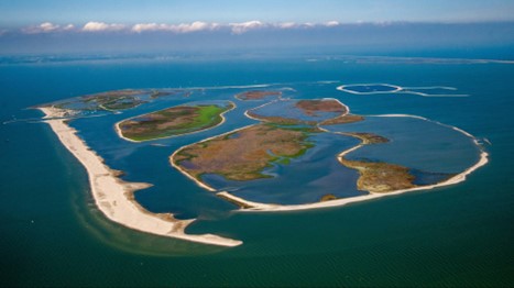
Aerial image
Encouraging biodiversity often involves the presence of vegetation that serves as a habitat for particular species. My role within the project was to detect, identify and monitor different vegetation types at the Marker Wadden using Remote Sensing data (in this case high- resolution satellite imagery and very high-resolution drone imagery of the area). Together with field experts from our ecology department, we generated ground truth data to train a Neural Network to detect and distinguish vegetation structures. The vegetation maps produced served as input for the evaluation and adaptation of ecological management. It was exciting to work on this project and thus be able to give nature a hand to heal.
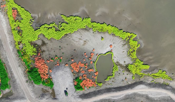
Snippet of the drone imagery with different vegetation types annotated/highlighted by colour
ℹ️ More about this project on the website of Witteveen+Bos
Investigation of measures to mitigate ground-borne vibrations induced by trains
According to CBS, 44.5 million tonnes of freight was transported by rail in 2022. As the railways are busy with commuter transport during the days, the increasing demand for freight transport by rail results in an increase in activities during the night.
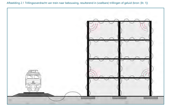
Within Witteveen+Bos, we were commissioned by Prorail BV through various projects to investigate the relationship between trains and ground borne vibrations. That is, vibrations induced by rolling stock propagating through the rails, bedding and soil and affecting the surroundings. The foundations of buildings near railroad tracks may capture vibrations, resulting in nuisances such as rattling cabinets and potentially causing sleep disturbances for residents.
One of the studies we conducted was specifically investigating the relationship between the travelling speed of trains passing by and ground vibrations induced by them. Specifically to investigate what the effect (desired: reduction in vibration intensity levels) is if the speed of freight trains during the night would be reduced.
Picture from onderzoeksrapport ‘Trillingsonderzoek praktijkproef gedifferentieerd rijden.’
This was done by conducting and analysing ground vibration measurements. As many train and environmental parameters are involved in vibration emission we used a Random Forest regression model to capture a relationship between input (specifically travelling speed) and output (vibration intensity). In doing so, we included the impact of vibrations caused by these trains on the ground and what this means for residents around the track.
Intuitively, you might think that lower speed leads to lower vibration levels, however, that does not always turn out to be the case. The measurements have shown that the effect is very location-specific, e.g. leading to a decrease in vibration levels at one location, and the opposite at another location. Also, many more parameters are involved in vibration emission than travelling speed alone. For instance, the weight of the train plays a role, and currently, we are involved in research into the impact of wheel conditions (e.g. flat spots, polygonization of wheels, ‘ovality’, roughness) on ground vibration emission. Flat spots for example emerge with sudden and severe braking, especially in emergencies, causing the wheels to lock up and slide on the rails.
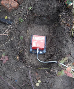
Syscom vibration sensor we used in the measurement campaign
ℹ️ Read more about this research in onderzoeksrapport ‘Trillingsonderzoek praktijkproef gedifferentieerd rijden.’ (Dutch article)
Automated detection of propane tanks
Currently, I am working on a project where we use an object detection model (neural network) to locate small (3500 litres or less) propane tanks in aerial images. Due to a change in legislation municipalities (or environmental services) are obliged to register these tanks as ‘hazardous activity’. The tool we are developing serves as a first inventory based on openly available aerial images of where these tanks are located. This inventory can be used to start getting the register up to date.
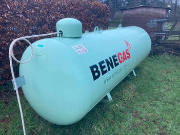
Propane tank
The areal images we use are annually collected and made openly available to be used by anyone. Some information is available at PDOK. We work with this dataset collected by aircraft as these images offer the best resolution, giving us the best opportunity to distinguish propane tanks from other tank-like objects (such as manure tankers, wrapped haylage bales, or -surprisingly- sheep). These so-called false positives have received much of our attention as these would introduce inconveniences during a manual inspection. Note that manual inspection and a field visit to the location will always be needed to collect and register all the required information.
One of the other challenges was how to analyse the entire country for propane tanks. We trained a neural network for the detection of propane tanks and divided the entire country into tiles of suitable size (512*512 pixels). Given that the ground resolution of the aerial images is approximately 8 cm, we end up with millions of images (tiles) to analyse. We added logic from the work field to reduce the number of tiles to process drastically. For example, we would not need to look for propane tanks in the water, hence we can skip the entire IJsselmeer. Same for croplands, meadows, and urban areas. Combined with the implementation of parallel processing we were able to end up with a reasonable processing time.
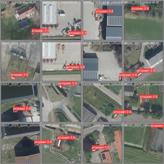
Model detection
Would you like to do an internship or a graduation project at Witteveen+Bos? Or if you want to learn more about the projects we worked on, take a look at the website under the heading ‘Career’ and/or ‘Projects’.


