From space to slums
Currently, 1.1 billion people live in slums—densely populated areas characterised by makeshift houses, poor sanitation, and precarious living conditions. By 2050, 90% of global urbanisation is expected to occur in low- and middle-income countries across Africa, Latin America, and Asia, where infrastructure often lags behind population growth. For example, in Nairobi alone, 60% of the urban population resides in slums that lack proper roads and adequate lighting.
“Government estimates of the number of slum dwellers are very rough, so the governments don’t consider the thousands of people living there. Often, with little or no warning, bulldozers destroy the little those people have because the government has other plans. But these are their homes,” says Dr. Monika Kuffer, a professor at the Department of Technology, Policy and Society at the University of Twente. She has been researching how remote sensing and spatial analysis can be used to monitor and understand deprived urban areas for over a decade.

Combining satellite imagery with local data, she exposes the harsh realities of life in rapidly urbanising regions of the Global South. “We use the data to highlight the scale of deprivation and advocate for better policies to support these communities.” For example, in a previous project, together with community-based organisations, she mapped waste accumulation in Nairobi, which helped convince local authorities to start collecting waste in slum areas.
Mapping the humanitarian crisis in Nairobi
“Nairobi has recently been hit by severe flooding caused by El Niño, resulting in significant loss of life and property. A small river turned into heavy torrents, destroying houses in informal settlements. In response, the government initiated a programme to demolish houses that weathered the flood, aiming to clear the areas prone to future flooding. This has left thousands of people on the streets. They don’t know where to go,” Kuffer says.
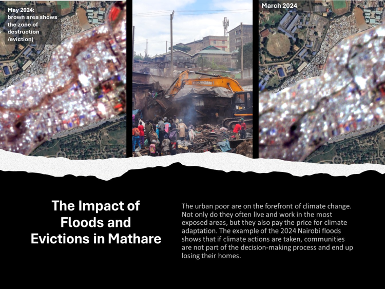
“Here, on the right,” she points to an image, "you can see a small river that winds through the settlement. Before the flood, the river appeared greenish, but now it is murky brown. The brown areas around the river aren't just waterlogged; those are also the sites of ongoing demolitions. Around 200,000 houses have been destroyed— partiality by the flood, mostly due to the evictions.”
Together with local groups, her SPACE4ALL team is actively mapping the extent of the damage. “Using satellite imagery, we provide local NGOs with evidence, so they can negotiate with the government for compensation and better responses. This documentation is essential, especially as local and international media remain silent on the continuing crisis.”
Flying toilets and power outages
In informal settlements, such as those in Nairobi, most areas are left in darkness at night. In addition to the danger of falling into unseen gaps on unpaved roads or being attacked in the dark, a troubling consequence is the use of flying toilets. “Without safe and accessible toilets at night, residents resort to using plastic bags, which are then discarded in the environment. This not only degrades living conditions but also poses serious sanitation issues. During floods, these bags are swept away, spreading waste throughout the area and causing disease outbreaks,” Kuffer explains.
There is a harsh discrepancy between official data and the reality on the ground. “Official databases claim that 100% of Nairobi's population has access to electricity, however, on-the-ground observations and high-resolution satellite data tell a different story. Many households, along with essential services like schools and health centres, frequently experience prolonged outages. For example, in Nairobi's informal settlements, power outages can last an average of three to four hours every other day. For the poorest residents living in mud houses, electricity access is often non-existent.”
Across Africa, many schools, hospitals, and health centres lack reliable electricity. "In places like Lagos, with an estimated 30 million residents, people spend much of their day without power. Imagine schoolchildren trying to study without reliable light: their educational progress is directly affected. Satellite imagery provides a more realistic picture of public space light. We use it as evidence to local governments, NGOs, and community organisations, such as CommunityMappers, to advocate for necessary changes.”
Challenges and limitations
Despite advancements in satellite technology, capturing nighttime images still has limitations. Kuffer explains, “Most of our current knowledge of night light comes from low spatial and spectral resolution sensors, for example, the Visible Infrared Imaging Radiometer Suite (VIIRS) and images from the International Space Station (ISS).
However, the most accessible satellite images (VIIRS) have a resolution of 750 by 750 meters: if there is a single unshielded streetlight within this area, it will indicate that the entire zone is illuminated. This means, for example, that power outages and poorly lit areas aren't accurately represented in those images. Official statistics might indicate an area is well-lit, but higher-resolution imagery (10 to 20 meters) could reveal that only a small fraction is lit.”
Kuffer’s team uses the Chinese satellite SDGSAT-1, which offers better resolution, but access is restricted and requires special permissions. “We need high-resolution images that are publicly available to highlight the needs of the most vulnerable urban populations. Urbanisation in deprived areas of the Global South remains largely hidden, but we bring it to policymakers' attention.”